Transit planning decoded
What is transit planning and how do data-rich tools enable agencies to deliver more sustainable, profitable and equitable systems?

Since the first public bus service launched in 1895, transit planning has been seen as a business of physical infrastructure. The fixed-route model, in which buses follow a predetermined route and pick up riders at set times along the way, is designed to transport the most people using the fewest resources possible. Schedules and routes, which are infrequently updated, largely cater to where and when most riders travel, leaving entire populations under or unserved, and agencies stuck running buses that may not be very efficient.
But the Transportation Network Company (TNCs) or ride-hailing boom of the 2010s flipped transit on its head. It demonstrated how mobility platforms, which use smartphone technology, open-source mapping and cloud computing, could create more reliable mobility options tailored to the specific needs of riders.
Today, the same kinds of mobility platforms that contributed to the success of Uber and Lyft have been adapted for public transit, enabling agencies to bring more bespoke multi-modal options like on-demand microtransit to riders. Mobility platforms don’t just help agencies operate these kinds of systems, they support their success by using robust data to help transit planners make informed decisions about how and where to run service and whom it would serve.
In this blog post, we’ll go over the fundamentals of data-driven transit planning and dive into how planners can leverage simulation tools like Spare Realize to run optimized, data-driven systems that result in more sustainable, profitable and equitable transit.
What is transit planning?
Transit planning involves the development and improvement of public transit networks, systems and routes. This can include fixed-route buses, microtransit, paratransit, non-medical emergency transportation (NEMT), ride hailing or any other form of transit that is available to the general public. The goal of transit planning is to provide safe, reliable and accessible means of moving people from A to B.
It’s a collaborative process that falls under the umbrella of transportation planning, which is part of urban design and guided by city planning.
How to leverage mobility data in transit planning
Mobility data describes how communities move or their travel patterns. It tells us where and when people are traveling, how they are getting there and why they choose a specific mode of transportation. This information can be obtained from various sources, such as travel surveys, mapping APIs, census and jobs datasets, national transit databases and General Transit Feed Specification feeds.
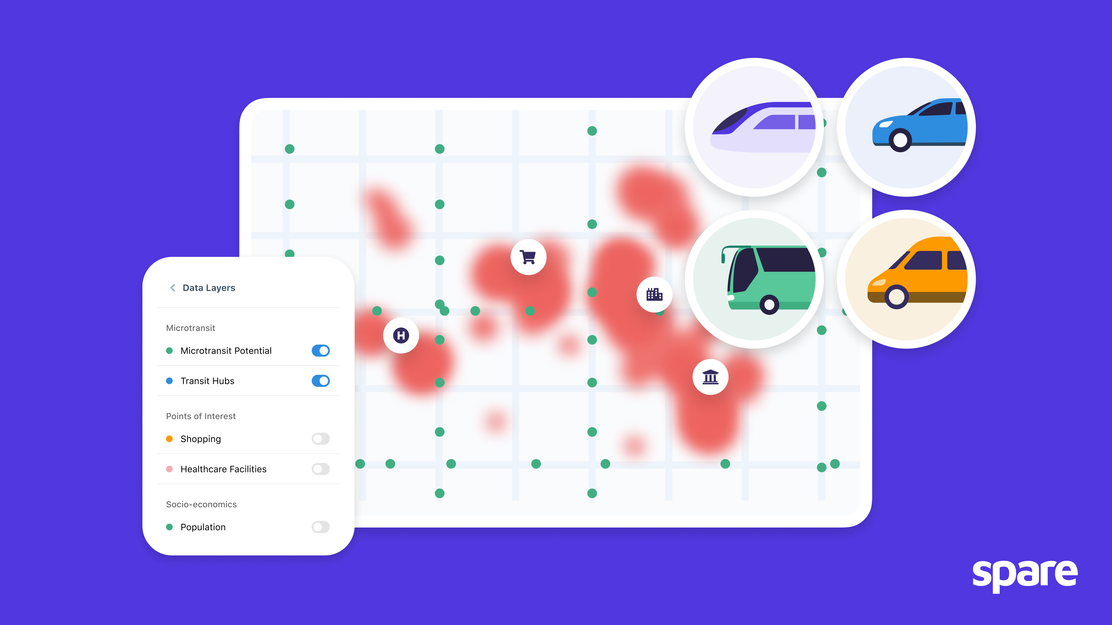
However, gathering data is one thing — visualizing and interpreting it is another. This is where tools like Spare Realize step in. Spare Realize helps planners visualize and simulate mobility patterns using advanced machine learning algorithms, allowing them to derive meaningful insights from their mobility data.
With effective planning tools, agencies can use mobility data to understand the 5 Ws of their riders:
- Who are your riders?
- What is their destination?
- When are they traveling?
- Where are they traveling from?
- Why are riders picking this particular mode of transportation?
Based on this information, planners can then identify when and where services should run in order to best meet the needs of riders. For instance, Spare Realize can pinpoint areas with steadily high transit demand, which are typically good candidates for fixed-route buses. Or it may indicate that an area has fluctuating travel volumes, making it a better fit for microtransit.
Spare Realize also allows transit planners to generate mobility data that helps them track the ongoing impact of services: did a new public transit route alleviate congestion in a heavily trafficked area? Has the morning and evening microtransit service addressed the first mile-last mile challenges for commuters living in a rural or suburban area?
The power of Spare Realize comes from its ability to simulate a limitless number of transit network scenarios based on the available mobility data. Services are then put to the test through prototypes which generate more data and ultimately allow planners to make informed decisions. On that note, let’s take a closer look at simulations and prototypes.
How to use simulations and prototypes
Prototyping involves the testing of a concept, process, or product before its release in order to evaluate its potential. When it comes to transit, rapid prototyping is invaluable as it allows planners to virtually simulate the benefits or pitfalls of various services or scenarios. Prototyping should be done during the planning process in order to ensure projects are fully optimized before they launch, as well as during their operation in order to continuously improve the service based on its goals.
Rapid prototyping involves:
- Establishing goals and key performance indicators (KPIs) that will help you measure service success using existing mobility data.
- Creating a virtual prototype zone around the communities you want to serve.
- Planning zone configurations such as service hours, stop locations and number of vehicles.
- Evaluating the impact of your service, including the costs and resources needed to operate, how it will benefit community members, how increased connectivity will affect areas beyond your zone, etc.
- Playing around with configurations and ridership scenarios in the simulations tool to see how changes could affect predicted outcomes.
Prototypes and simulations are especially important for microtransit planning. As fixed-route transit faces competition from uber convenient mobility options such as ride hailing services, on-demand microtransit has emerged as an ally that can help bridge the accessibility and convenience gaps faced by fixed-routes. While the concept of microtransit isn’t new, its true potential has been overlooked due to the lack of technology necessary to plan and integrate successful microtransit networks. Thankfully, planning tools like Spare Realize have busted the myths that microtransit is too risky or costly through prototypes and simulations.
By prototyping microtransit services, agencies can generate rich datasets that enable them to determine things such as where and when demand exists, and the best locations and hours for fixed bus routes, allowing them to run efficient, optimized transit networks.
How to drive equity with transit planning
Transit planning based on robust data, including data on underserved populations, can lead to affordable, safe and accessible transit services for those communities. This is important because access to quality, convenient and effective transportation is the strongest factor in escaping poverty in the United States.
However, transit equity can be challenging to evaluate due to the breadth of ways transit impacts peoples’ lives. This is why it’s so important to begin planning on a foundation of data that paints a picture of a community’s needs. Those needs should form the basis of equity-related KPIs and we should measure success on whether or not they are being met.
Data-based transit planning can help achieve and track those equity metrics through simulations, giving planners a sense of how service configurations will affect communities before they’re implemented. For instance, if the data shows that a low-income neighbourhood uses a service for much shorter trips during off-peak hours, while a more affluent one uses the same service for long trips during peak hours, planners can consider implementing a variable fare structure that charges based on factors such as time of day or distance traveled. This helps ensure that the lower-income riders are not subsidizing the more operationally expensive trips of the higher-income passengers.
Relying on simulation tools can allow transit planners to make a difference in the communities by drastically improving connectivity in both urban and rural areas alike. If you want to learn more about how Spare can help your on-demand transit service leverage simulations and prototypes and make data-driven decisions, or about our dedicated simulation tool, Spare Realize, drop us a line at hello@sparelabs.com.